Introduction
TerraBio includes standardized indicators to compare performance between and across different interventions. This informs on not just performance of a management practice to achieve their desired outcomes, but also enables comparison and learning from activities in an effort to continue to refine management decisions and prioritize investments with large impacts… These indicators include land cover and land use indicators such as number of hectares directly restored due to intervention practices, biodiversity indicators such as change in key species groups at investment site, and landscape integrity indicators with the number of hectares conserved showing increases in key species.
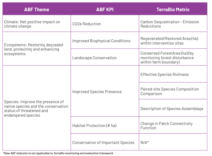
TerraBio indicators are aligned and respond to ABF Key Performance Indicators (Table 1).
Table 1. Summary of reporting details for each remote sensing based metric

Remote Sensing Indicators Reporting Units
We calculate the four remote sensing based metrics across different geographic regions. Some are reported at the farm level, while others are reported by land use. Table 1 lists the indicators, metrics, reporting units and measurement units for each of the remote sensing derived metrics.
Table 2. Summary of reporting details for each remote sensing based metric
| ABF KPI | TerraBio metric | reporting unit | measurement units |
|---|---|---|---|
| CO2 e Reduction | Carbon Sequestration - Emission Reductions | farm boundary and by land use | tons CO2 equivalent removed, normalized by area |
| Improved Biophysical Conditions | Regenerated/Restored Area | within intervention sites and farm total | Total ha |
| Landscape Conservation | Conserved Forest Area | farm boundary, excluding intervention | Total ha |
| Habitat Protection | Change in Patch Connectivity | farm boundary | percent area change per class |
Biodiversity Indicators Reporting Units
We calculate three biodivreisty metrics.
| ABF KPI | TerraBio metric | reporting unit | measurement units |
|---|---|---|---|
| Improved Species Presence | Effective Species Richness | farm boundary and by land use | number of species |
| paired-site species composition comparisons | farm boundary | unitless value (0-1) | |
| description of species assemblage | farm boundary | total hectares |
Unpacking the Geographic Reporting Units
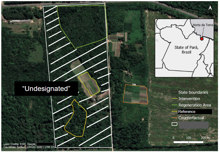
The land uses we include in the design of TerraBio include:
- Reference: Conserved forested area characterized by native trees.
- Counterfactual: Practice followed if no intervention. E.g. pasture land, soy plantation.
- Intervention Type(s) [Not all deals will have each of these land uses]:
- The agroforestry system or reforestation sites (the business implementation).
- Regeneration site: Any area left for regeneration/natural succession or managed restoration.
- Undesignated: Note, not all areas in a farm will fall under these categories. We refer to this area in the farm that is not included as an intervention, reference or counterfactual as undesignated.
- Farm boundary(ies): Includes the farm boundaries under the deal. It usually encompasses all the other land uses, but it can happen that one land use is not within the farm boundaries.
Below we include some images to illustrate what these different reporting geographies could look like for a deal. 
