1. Generate a forest/non-forest map for 1985-current year
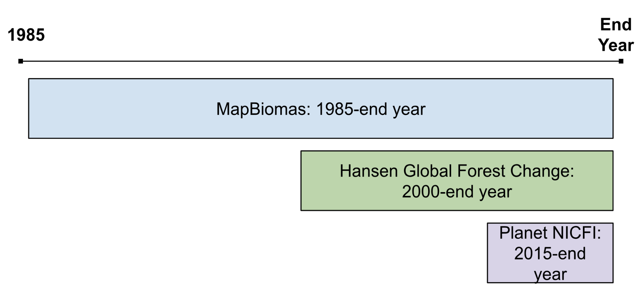
The forest/non-forest (F/NF) layer was constructed from three datasets: MapBiomas, Planet NICFI and the Hansen Global Forest Change product. The goal is to include as much forest as possible, choosing to err on the side of overestimating. This layer is used solely for stand age calculation.

| Product | Notes | Source |
|---|---|---|
| MapBiomas | In the past, MapBiomas was found to underestimate forest cover in Horta farm. Class descriptions: https://brasil.mapbiomas.org/wp-content/uploads/sites/4/2023/08/EN__Codigos_da_legenda_Colecao_7.pdf | https://brasil.mapbiomas.org/en/ |
| Planet NICFI | Used training images from 2017. Built classifier on images across season, not just dry season. Because we found that limiting the images to one season does not make a difference. | https://developers.google.com/earth-engine/datasets/catalog/projects_planet-nicfi_assets_basemaps_americas |
| Hansen et al. Global Forest Change Product | To generate the actual F/NF mask, we used the loss year and the bitmask that indicate if gain occurred in 2000-end year. | https://developers.google.com/earth-engine/tutorials/tutorial_forest_02 |
2. Map forest cover and stand age at annual increments
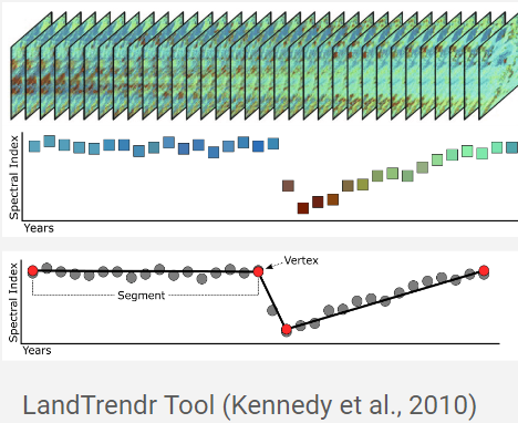
We use the LandTrendr algorithm to map stand age from 1985 to today. LandTrendr (Kennedy et al., 2018) uses statistical analysis procedures to simplify a time-series of spectral values into a sequence of connected straight-line segments that capture the overall shape of each location’s spectral index pattern over time– while omitting noise. The resultant segments can then be used to classify forest dynamics and stand age.


Set LandTrendr Parameters
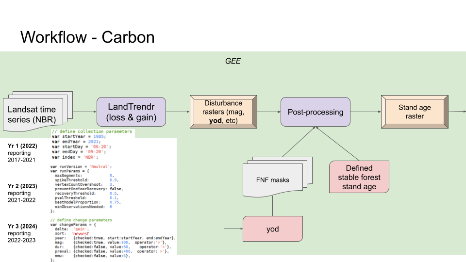
We use LandTrendr, implemented in GEE, to map stand age. The Kennedy et al. (2010) paper describes LandTrendr, an algorithm that detects changes (decrease or increase) in forest canopy. This is the foundation that we use to date when forests or trees have started to regrow. We used the Normalized Difference Fraction Index (NDFI), as it is more sensitive to change than NBR (which is used for the LandTrendR run that feeds into the regenerated/restored and conserved forest metrics).
Setting the Time frame
We will run the analysis going back as far in time as possible, since we want to be able to assign a stand age to all stands – even those that are old. So our mapping time frame goes back to 1985, when Landsat images were first collected. We use Landsat 5-8 Surface Reflectance for 1985-2021.
Some trees, or stands of trees, were established prior to the collection of Landsat data in 1985. In these cases, we need to assign an age of establishment. In these cases, we have set the age of these stands to 37.5 year, based on conversations with partners ** update with more details on how we chose this number **.
Making this operational
Often, multiple runs are needed in order to fully customize the LandTrendr algorithm to the local area, and we record these tuned parameters in the data dictionary. ** update with details on the parameters we chose **
3. Apply Logic Rules to Assign Yearly Per-Pixel Stand Ages
- Classify regrowth age from areas of identified Landtrendr forest gain for each time step.
- Classify loss events, secondary forest, and secondary forest stand age as locations where current land cover is forest and a loss event occurred.
- Year of loss from LandTrendr (and/or year of loss from Hansen global forest loss), then compile to determine the most recent year of loss.
- Determine loss area age by subtracting year of loss from current year.
- In forests, identify locations that are currently forest but a loss event has occurred in the past. Classify the stand age of these locations as the age since lost.
- We repeat this process for each time step (e.g., we are interested in calculating carbon over a 5 year baseline).
- Classify secondary forest and secondary forest stand age as locations where current land cover is forest and a gain event occurred.
- Take the stand age determined, the forest mask, and annual LandTrendr regrowth age. In forests, identify locations that are currently non forest, but a gain event occurred in the past.
- The stand age of these locations is equal to the regrowth age. Repeat for each time step.
- Classify mature forest and mature forest stand age as locations where current land over is forest and no disturbance events have occurred.
- In forests, identify locations that are currently forest and have an unknown stand age. You may need to make assumptions about stand age (e.g. assume forests that have not been disturbed are 40 years old at the start date).
- Classify the stand age of these locations accordingly.
- Compile the information from steps 5, 6, and 7 sequentially into a final stand age of forest layer.