Conserved Forest Methodology
TerraBio’s landscape conservation indicator monitors forest land cover areas by estimating and subtracting forest disturbance. By forest disturbance TerraBio distinguishes between deforestation and degradation.
The Land Cover Change image helps us understand how the landscape has changed over time. Landscape conservation is calculated as the number of hectares classified as stable forest within the farm property but excluding the intervention site. The areas are mapped using the LandTrendr algorithm which leverages time series analysis using Landsat data and is explained above. The algorithm was parameterized to estimate the “greatest” loss (herein, disturbances). Forest disturbances include high-impact events, such forest loss from fires or deforestation, to subtle and gradual processes, such as degradation caused by prolonged droughts, insects, or diseases (Cohen et al., 2017; McDowell et al., 2015). Deforestation is defined as a long-term or permanent conversion of forested land to non-forested land (FAO, 2001). While there is not a widely accepted definition, degradation here is defined as a long-term process that does not lead to a land cover change but negatively affects the forest’s structure and function (Sasaki and Putz, 2009; Schoene et al., 2007).
Disturbances (deforestation/degradation) and non-disturbance (forest/non-forest) areas were classified as deforestation and degradation using forest/non-forest (FNF) annual images (2017-2021) from a supervised classification using Planet NICFI imagery (downsampled to 30 meters to match the LandTrendr results). Disturbance areas were relabeled as deforestation if the pixel in the FNF image at the end year was labeled non-forest, and as degradation, if the pixel was labeled forest. Non-disturbance areas were classified into stable forest if a pixel was always labeled as forest from 2017 to 2021, and as non-forest if otherwise.
Reporting details
We calculate this metric within the farm boundary.
Table 1. Summary of reporting details | ABF KPI | TerraBio metric | Reporting Unit | Measurement Unit | |————————|———————–|—————————————|——————| | Landscape Conservation | Conserved Forest Area | farm boundary, excluding intervention | Total ha |
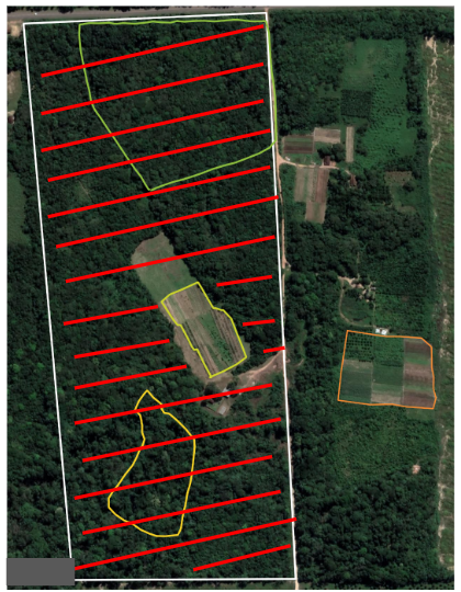
This metric is calculated across the Farm Boundary, but excludes the Intervention site (see red hatchmarks in image below for an example of what this geographic unit could look like).

Methods Overview
- Remote Sensing Product: change map
- Input Data: Landsat time series (NDFI), tree cover mask, ?potential forest?
- Methodology: LandTrendr, image interpretation in CEO, area analysis
- Computing Environment: GEE, CEO for validation/area estimation
- Output: Map with 5 classes:
- Stable forest
- Non-forest
- Degradation
- Deforestation
- Regeneration
Accuracy CCURACY ASSESSMENT OF MAPPING PRODUCTS
An independent validation effort was conducted leveraging high- and medium-resolution optical imagery (Planet NICFI mosaics, Google Earth Pro basemaps, Sentinel-2, and Landsat Collections) and ancillary datasets (MapBiomas products, the Global Forest Canopy Height 2019, and NDFI time series) to assess classes on the ground [60-65]. Visual interpretation was done in Collect Earth Online (CEO), a free and open-source web-based tool that facilitates data collection and validation [66-67]. The interpreter utilized a decision tree approach for classifying the validation samples.
For the validation of the disturbance and regeneration maps, the sample points were 30 by 30 meters square, mimicking the map output pixel sizes. The validation of both change maps (disturbance and regeneration) was done using the same set of points. We also used a simple semi-random sampling design with proportional class distribution where we extracted 600 points from both maps, therefore, 100 points for each class: degradation, stable non-forest, stable forest, deforestation, regeneration, different events (Table S1). A “different events” category was used to capture locations where the mapping methods determined a different class for the same location. This class can include regeneration events on non-forest areas followed by degradation or deforestation or disturbance events, most likely deforestation, followed by regeneration. The accuracy metrics (overall, user, and producer accuracies) and unbiased area estimates for each class were calculated through the ratio estimator approach [68] for when the strata are different from the map classes since we used the same sample points for disturbance map and regeneration map.
Farr, T. G. et al., 2007, The Shuttle Radar Topography Mission, Rev. Geophys., 45, RG2004, doi:10.1029/2005RG000183
- Olofsson, Pontus, et al. “Good practices for estimating area and assessing accuracy of land change.” Remote Sensing of Environment 148 (2014): 42-57. https://doi.org/10.1016/j.rse.2014.02.015.
- ESA, 2015. SENTINEL-2 User Handbook, vol. 1, pp. 64.
- Buchhorn, M., Lesiv, M., Tsendbazar, N. E., Herold, M., Bertels, L., and Smets, B. (2020). Copernicus global land cover layers—collection 2. Remote Sensing, 12(6), 1044.
- Planet. (2021) Planet and NICFI partnership data
- Potapov, P., Li, X., Hernandez-Serna, A., Tyukavina, A., Hansen, M. C., Kommareddy, A., … and Hofton, M. (2021). Mapping global forest canopy height through integration of GEDI and Landsat data. Remote Sensing of Environment, 253, 112165.
- Bey, A., Sánchez-Paus Díaz, A., Maniatis, D., Marchi, G., Mollicone, D., Ricci, S., … and Miceli, G. (2016). Collect earth: Land use and land cover assessment through augmented visual interpretation. Remote Sensing, 8(10), 807.
- Saah, D., Johnson, G., Ashmall, B., Tondapu, G., Tenneson, K., Patterson, M., … and Chishtie, F. (2019). Collect Earth: An online tool for systematic reference data collection in land cover and use applications. Environmental Modelling and Software, 118, 166- 171.
- Stehman, S. V. (2014). Estimating area and map accuracy for stratified random sampling when the strata are different from the map classes. International Journal of Remote Sensing, 35(13), 4923-4939.